
Website Search
Displaying results 26 - 50 of 306
Mariam and Wayne discuss the rich history of baseball in Kentucky.
Mariam and Erin discuss and play clips of a few of their favorite moments from Tales from the Kentucky Room. This episode was recorded online from their homes.
Mariam and David discuss Charles Dickens’ visit to Kentucky in 1842, with readings by Bill Widener from Dickens’ work “American Notes.”
See what's currently on display at our art galleries.

Located in the Tates Creek Branch rotunda.
Jennifer and Erin review recipes from four Kentucky Cookbooks: Southern Girl Meets Vegetarian Boy by Damaris Phillips (Pimiento Cheese Baked Rice), Bluegrass Gatherings: Entertaining through Kentucky's Seasons by Junior League of Louisville (Beer Cheese),
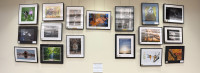
A gallery featuring photography by the Creative Camera Club.
Search, view, and download digitized historical Lexington, KY Newspapers covering the 18th, 19th and 20th centuries.

A 1,200-square-foot gallery that features a wide variety of art by local and regional artists. A participating gallery at Gallery Hop.

A 31-foot gallery wall that features a wide variety of art by local and regional artists.
The Lexington Public Library has made an effort to ensure that all of our digital collections are public domain, or that we have gotten approval from the copyright holders to display their work. Most - but not all - of these collections, to the best of our knowledge, have no known US copyright restrictions. Some items in the collection are under copyright but qualify for online display by libraries under Section 108(h) of United States Copyright Law. Some of the collections provided in the Library's Digital Archives are made available under an assertion of fair use, which does not necessarily apply to an individual's use of them.


